NOTE
To be code compliant in San Diego, analyses need to be based on climate zones as recognized by the California Energy Commission - which vary from other sources. However, within a CEC climate zone, energy engineers may improve their analysis by obtaining data from weather stations located either more nearby their project site or from a weather station in a microclimate that is similar to the project site - where the data from the CEC climate zone is too general to reflect the variation in project site conditions due to it being in a microclimate.
Tip
If you’re looking for data to calculate cooling and heating loads, see: HVAC Outdoor Design Conditions
California Energy Commission Climate Zones
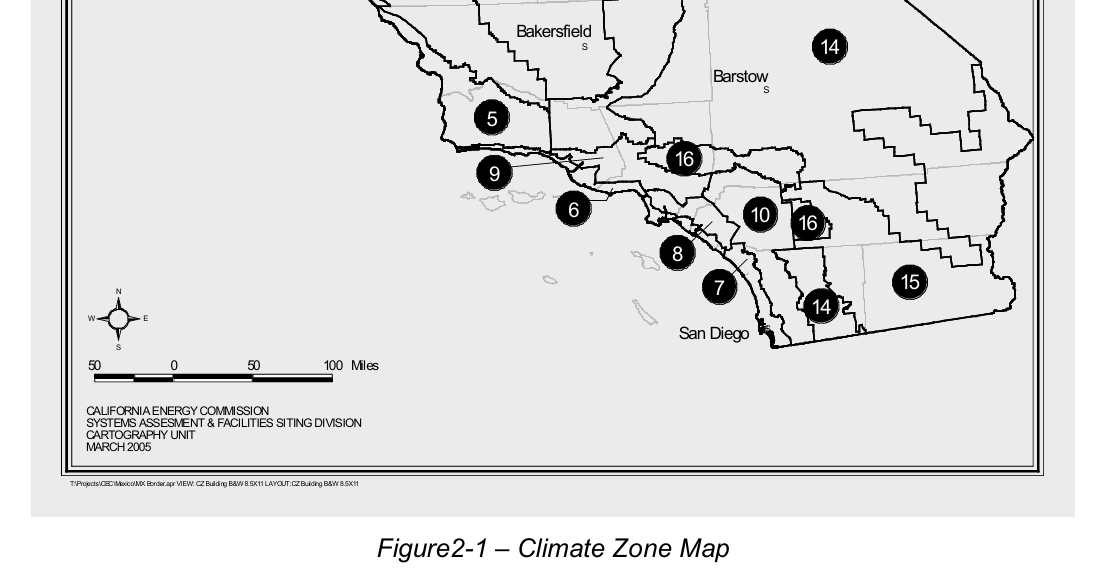
The California Energy Commission / California Energy Code account for variations in weather across California using a set of 16 climate zones.
The CEC also provides the EZ Building Climate Zone Search Tool which can be found, along with other climate zone resources, at this page:
San Diego is divided into:
- CEC climate zone 7
- CEC climate zone 10
- CEC climate zone 14
- CEC climate zone 15
CIMIS
The California Irrigation Management Information System (CIMIS) divides San Diego County into six climate zones: Coastal, Coastal Inland, Upland Central, Transition, Mountain and Desert.
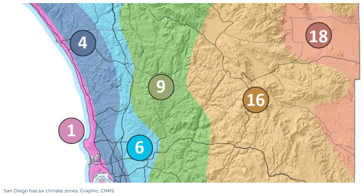
Zone 1: Coastal Prairie The Coastal Prairie zone hugs our county’s coastline. It is the zone most strongly influenced by the ocean, with a mild marine climate resulting from the warm Pacific Ocean. Winters are mild, summers are cool, and there is almost always moisture in the air.
Zone 4: South Coast Inland
South Coastal Inland areas are just inland from the beach, or on high bluffs above the coastline. You can feel the ocean breeze, but you can’t taste the salt in the air. There is less fog and humidity than the immediate coastal area, and higher temperatures.
Zone 6: Upland Central
The higher elevation Upland Central areas are influenced both by moist coastal air and dry interior air. Humidity, morning fog, and wind are moderate, with low annual rainfall.
Zone 9: Transition
This marine-to-desert transition climate is farther inland. It features a combination of warmer thermal belts and cold-air basins and hilltops, with occasional marine influence. The climate can vary from heavy fog to dry Santa Ana winds.
Zone 16: Mountain
Steep slopes, variation in sun and wind exposure, shallow soils and heavier rainfall affect plants in the Mountain regions. Average annual rainfall is 30 inches, and wet years can bring 45 inches or more.
Zone 18: Desert
Dry and hot daytime conditions combine with cold nighttime temperatures in the Desert zone. Humidity is very low, and water is scarce. Average annual rainfall can be as low as 2.5 inches, with an average of just 6 inches.
ASHRAE
ASHRAE publishes several resources for working with weather data: https://www.ashrae.org/technical-resources/bookstore/weather-data-center
NOTE
As recently at 2025, the Title 24 Reference Appendices provide design data for California which is based on:
"ASHRAE Climatic Data for Region X, Arizona, California, Hawaii and Nevada," Publication SPCDX, 1982 and “Supplement,” 1994This is interesting because the data is, at minimum, over 30 years old and at this point, in relation to Climate Change, its validity is debatable.
**ASHRAE Technical Committee **
Ongoing development of weather data is facilitated by ASHRAE Technical Committee 4.2: Climatic Information
- Scope: TC 4.2 identifies, researches, analyzes, and disseminates climatic data for design of sustainable built environments.